
Village Nitrianska Blatnica.
The first written record of the village comes from 1185 in the Stojslav’s Testimony.
The history of the village reaches up to the age of Great Moravia (the 9th century). Its original dwellers lived approximately 5 km northwards from the today’s village, beneath the Krahulčie Mountains under the Marhát Mount (758 m) in the surrounding of the small church – Rotunda of St. George. The St. George holy shrine was said that the chapel was built by Maria Thurzo in 1530. Only the archaeological research (1976 – 1980) found out that it is the settlement from the Great Moravian age from the second half of the 9th century, from the period of Svatopluk’s reign. The village dominates the big classicistic Church of Exaltation of the Holy Cross. It gave be built in 1821 by the count Pavol Zerdaheli. North from a church in a park there is the Renaissance manor-house (1578) with the medieval bastion (the 15th century), the elementary school area and the sport and recreational centre. The House of Culture includes the museum exposition from the archaeological excavations on the village territory and its close vicinity. On the square there is the Monument devoted to the Victims of the I. and the II. World War.
Nitrianska Blatnica is geographically set on the north-western spur of Podunajská pahorkatina and south-western spur of Považský Inovec. It stretches on the area of 1439 ha. The highest peak lies in the area of Kukučí vrch, right on the border with the Vozokany village lying in the north-eastern portion of the cadastral map. The lowest point (214,3 AMSL) is in the southern portion of the cadastral map, bordering with the Krtovce village.
The oldest primeval settlement dated to the late Bronze Age was found in the ground plans and geological sections made by a big research probe in the Púsť meadow. The archaeologist exposed also a double-room dwelling dated back to the 12th century, which was built at the ground level. It had wooden rustic structure with the floor reinforced by smaller rocks. In the vicinity of the dwelling, big circular stove was found. Since 1973, the archaeological research has been focused on the early medieval phase of settling the vicinity of the St. George Church (Jurko). It is believed that the construction of the rotund started back in 9th century. Its first destruction and reconstruction are dated to 10th -11th century, the second reconstruction was presumably carried out in 13th century. The renaissance construction of the rotund, which took place around year 1530, was a duly adaptation of the remnants of older structure. There was a cemetery near the rotund with 126 documented graves. The oldest graves originate in 10th-11th century. During the early medieval age, the iron ore mining was developed at the Marhát Mountain. This shall be one of the main potential reasons for the early settling, which involved developed iron production dated back to 9th century.
The name “Blatnica” is very ancient and denotes local waterlogging of soils. The question is, if it was the original name and only Hungarian notaries and clerks in the royal office named it by the Hungarian version “Sarfew”. The most ancient history of the settlement is connected with the noble family of Hont-Poznan, or Nitrian Poznan family, which owned the whole area at least since 10th century. The oldest famous ancestor was the peer Chanad, who lived in the second half of the 12th century. He had the only son – who, according to the generic tradition – was named by an old Slavonic name Stojslav. This young man participated in the crusade with the king Belo III towards the end of the year 1184, but he was seriously injured. However, he managed to return to the native Blatnica and he wrote the testament in the anticipation of his close end. The 1352 copy has been intentionally cut apart and only right half of the document was preserved. However, we know that Stojslav bequeathed the estate named “Blatnica” (predium, quod dicitur Sarfew) to his mother together with six serf settlements. This testament discloses also the first names of Blatnica inhabitants. Small Blatnica demesne contained only three villages; Blatnica, Krtovce and Lužany. At the end of Máté Csák-Era, the family owning Nitrianska Blatnica found itself in rather peculiar situation. The grandfather Mikuláš joined the party of the king Charles (I.) Robert and became a Duke of Transylvania; however his grandson Michael was a loyal supporter of the Trenčín Oligarch till the end. At the beginning of 15th century, the Blatnica demesne changed the ownership and got into the hands of peers from nearby Ludanice, more specifically Thomas, Bishop of Eger and his brothers Stephen, Ladislav and Synko. On April 27th, 1437, King Sigismund decided to give the castle in Nitrianska Blatnica together with the Blatnica municipality and other appurtenances to his old counsellor and vassal Štefan of Zend and his two sons Mikuláš and Štefan. Towards the end of the medieval period, Blatnica retained its status of privileged feudal municipality with the right to organize weekly Wednesday’s fairs.
The members of Kálnaj family, who owned Nitrianska Blatnica at the time of the Battle of Mohacs, died in the battle. During the first Ottoman invasion in our territory, 21 “portas” (houses with yards) were burned down in the town. At the end of the 1540’s, the land and the serfs were owned by another magnate family of Čechov. The gentry family of Zeleméry (with second surname Kamaráš) became another owner of the village, after Anna Dobó got married to Ján of Zelemér. Their son, Ladislav Zeleméry was the first one from this family, who settled down in Blatnica. It’s very likely that it was him, who reconstructed and fortified the old Kalnaj hall, so it changed to a renaissance mansion. When the family died out, all their shares together with the mansion became a property of Dóczy family. After them, the property shares in Blatnica were taken over by Esterhazy family. Until the second half of 18th century, Blatnica was a feudal town. The ambient municipalities (Bojná, Radošina, Preseľany) took advantage of its later stagnation and became towns, and Nitrianska Blatnica lost its privileged status. The citizens lost also their privileges in case of wars and fires, as they informed the representatives of Nitra county in 1769. The history of the demesne was influenced also by gentry families of Berényi, Bošányi and Príleský. More then two thirds of the demesne with the mansion were owned by the educated member of gentry, archivist and courtly counsellor, but also the forger of medieval documents, Adam Rajčáni, who is buried in Nitrianska Blatnica. The citizens, who had many arguments with Tematín demesne, were agrarian and they were cultivating grapes. In the mountainous area, the mountain sheep farming prospered as well. There were two mansions in the town. Moreover there was another noble house (hall) and a house of a military captain. Church supported by the landlords sustained a poorhouse (xenodochium) in the village, which served as a hospital. In 1787, Blatnica was attacked by two earthquakes causing the destruction of a newly built tower and the church itself was damaged to such an extent, it must have been dismounted. By the earthquake destructed Blatnica was reconstructed by Czech and Moravian bricklayers and carpenters, who ended up settling here.
In 19th century, the gentry family of Zerdahely from Nitrianska Streda became the major owner of the village. They came to Blatnica from Hajná Nová Ves in 1796. Pavol Zerdahely reconstructed the Blatnica mansion and initiated the construction of new Blatnica church, which he is also buried in. His son Viktor renounced the property in favour of Baroness Maria Adamovičová, who pawned it to Karol Appel in 1838. Thereafter, an Austrian business family of Alojz Haase gained the demesne.
In 1848, Ján Mišík, the village intellectual and Zerdahely’s serf rebelled against the martial law. On September 25th, 1848, J.M. Hurban sent a letter to Blatnica, ordering the whole “Šarfická village” to uniformly rise up for its freedom.
In 1870’s Kurt Leonhardy took over the whole Appel demesne. During the land consolidation, the urbarial land definitively became a property of farmers. The consolidating activities, the land surveying and cadastre mapping ended in November 1878. In 1865 and 1866, extreme frosts and heavy thunderstorms damaged the vineyards and seeding in the fields. The grapes and almost all fruits froze. Towards the end of 1870, the destruction of local vineyards was completed by the grape phylloxera. According to the economical statistics dated to 1895, there were no vineyards in Blatnica any more. Since the World War I the demesne had been rented by Jakub Lampl and Redlich.
In 1883 a Post office was established in Nitrianska Blatnica. There was one pub run by a Jew Marcel Schluessler together with his son Viliam. The Jewish House of worship was situated in the Shoemaker Mark Rosenfeld’s house and workshop.
The self-administration was an important part of the municipal life. Regular elections for the Mayor and other authorities had to – according to the Municipalities Act, 1870 – take place annually. The Mayor, Vice-mayor and three Jurors were elected from at least three candidates. Together they formed a Municipal Board. Based on the new Municipalities Act, 1886, Nitrianska Blatnica gained a status of a small municipality.
After formation of Czechoslovakia in 1918, Nitrianska Blatnica belonged to the Topoľčany district, later in 1923 – 1949 to the Nitra district and then again to the Topoľčany district. The connection with the Nitra town was enabled by the railway and as of 1928, there was a bus connection established to the towns of Topoľčany and Piešťany. During the depression period in 1920’s and 1930’s there was a high unemployment rate in the village. Many people went abroad to look for jobs, mainly to USA and France and many of them stayed there forever. In 1920 – 1921 there were several strikes in the Leonhardy’s demesne; the strikes were organized by a Communistic party. During the first Czechoslovak republic (1918 – 1938), the first land reform was carried out. In 1931, the village became electrified. Cultural life was provided by an Amateur theatre, which performed mainly dramas by Ferko Urbánek. There were several guilds, the oldest of which was a Firemen’s guild established in 1927. Many citizens participated in Slovak National Uprising. The village was liberated on April 2nd, 1945. In May 1945, the first local national committee was assigned, administrating the village until 1990, when the self-administration of the village was re-established. After February 1948, the administration was fully overtaken by Communists. The private sector was eliminated and in 1949 the Uniform agricultural cooperative was established, which is still in operation, after its transformation into the agricultural coop in 1992. Within the scope of post-liberation Five-year plans, the construction of municipality started and many public buildings were built or reconstructed; the Culture centre in 1978, shops, local roads as well as new modern single houses. After 1990, many prospering companies grew in Nitrianska Blatnica, providing jobs for village citizens. During the last 20 years, many structures improving the standard of living were constructed.
First school was established by Benedictines near the St. George’s Church. The tradition of hermitage at the St. George’s Church was vivid until the first half of 19th century. After Benedictines, the Franciscan friars from Hlohovec were teaching at school at St. George’s. Later records about Blatnica’s teachers are dated back to 18th century. There was also a girls’ school in Blatnica with a prominent patroness, Maria – the wife of Kurt Leonhardy. After 1918, the school in Nitrianska Blatnica was still administrated by Roman-catholic church. The school had constant problems with teachers and the deteriorating building. Finally, on September 1st, 1928, Ferdinand Oravec came to Blatnica and spent 38 years in here. In 1945, the school was nationalized. The new building of the school was constructed in 1962.
The written sources confirm the existence of a parish in Nitrianska Blatnica in the beginning o 14th century. In 16th century, the parish was taken over by Protestants and as the 17th century began, it became Catholic again.
The folklore of the Nitrianska Blatnica village has its roots in the agriculture, which combined with the farm and livestock animal breeding, represents the old and traditional employment of the Blatnica’s citizens. From the viewpoint of the settlement form, Blatnica is a collective village developed from the original build-up area, with the settlement axes determined by the road. Up to the 1930’s-1940’s, the most widely spread type of traditional courtyard building was a single-sided yard building. The traditional cuisine in Blatnica had a self-subsistent character, rarely using the items gathered from the natural environment.
People were buying only such groceries, which they could not have acquired from their own sources. Traditional clothes in Blatnica belong to the western Slovak type, more specifically to the one of the subcategories of Nitra variation. The complex of traditional folklore rituals is bound with two basic phases of the solar cycle – winter and spring season. The period of winter solstice is rich with different rituals. From the viewpoint of ceremonies connected with the important periods in human life, the most important are birth, marriage and death. These events were accompanied by many habits and customs.
There are several cultural sights and monuments in Nitrianska Blatnica. The renaissance mansion belongs to the most distinguished ones. The reconstruction of originally medieval mansion was associated with Ladislav Zelemer. It was completed in 1578. Baroque construction activities in 17th and 18th century changed the mansion radically. Another structure is the medieval bastion, which was a part of middle-age fortification system of the mansion. At the beginning of 20th century, Leonhardy family transformed the building into the chapel.
Among other cultural sights, there is a landscape park established in 18th -19th century, medieval graveyard, Count Pavol Zerdahely monument and a baroque organ in the Church of the Elevation of the Holy Cross (1740-1750).
The sports started to develop in Nitrianska Blatnica in the 1950’s. First sportsmen were the skiers using the home-made skies. First rag balls appeared in the school and children played football while shepherding geese, goats and cows. First football pitch appeared in the area of “Za borinou”. Nowadays, the adult team plays in the highest district league – district championship. Another popular sport in the village is a ninepin bowling. First bowling place was open shortly after the end of World War II by Michal Toman senior in the garden of his pub.
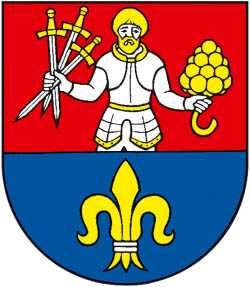
Since 2000, the village uses its own signs; the coat of arms, the flag and the seal. Coat of arms contains a divided red-blue shield, on the top half of which there is a knight with golden hear and golden beard – St. Mauritius – holding three silver swords with golden hilts in his right hand and upward directed golden bunch of grapes in his left hand. In the bottom half there is a golden lily, twice engirted by silver.
The Educational Trail Považský Inovec.
The Educational Trail Považský Inovec, according to its name, runs across the area of the Považský Inovec mountain range. It starts in the southern part of the mountains, in the municipality of Šalgovce and leads to the north up to the water reservoir in Nemečky, Kulháň and to the municipality of Ducové on the Váh riverside. The trail runs through the municipalities of Šalgovce, Ardanovce, Radošina, Nitrianska Blatnica, Vozokany, Lipovník, Hubina, Ducové, Bojná, Tesáre, Závada, Podhradie, Velušovce, Prašice (Duchonka) and Nemečky.
Theme of the trail: historical, cultural, natural-scientific, and environmental • Type: self-service, textual, graphical, sommer and winter, linear • Degree of difficulty: medium to difficult • Length: approximately 60 km (including side trails) • Protected areas: NKP St. George Rotunda, CHPV Čertova pec Cave, ÚEV Hradná dolina, PR Holé brehy • Geomorphologic unit: Považský Inovec, Krahulčie vrchy
Location and Characteristics:Považský Inovec is situated in the western Slovakia and belongs to the Fatra-Tatra region. It is 48 km long and 15 to 25 km wide. The mountain range is most massive in its northern part, neighboring with the Strážovské vrchy mountains, dominated by the highest peak Inovec (1042m). The mountain range gradually descends to the south towards the Danube Lowland (Podunajská nížina), which surrounds the mountains. Geomorphologically the mountains are subdivided into: Vysoký Inovec (Inovec 1042m), Nízky Inovec (Bezovec 743m), Krahulčie vrchy (Marhát 748m) and Inovecké predhorie (without any outstanding peaks, to the east of Beckov 550 m above sea level).
Landmarks. Among the most important historical landmarks in the area there is the Great-Moravian castle Kostelec near Ducové, St. George Rotunda near Nitrianska Blatnica, Great-Moravian hill-fort in Valy nad Bojnou, as well as medieval forts in Beckov, Topoľčany, Tematín and Hlohovec, which was later rebuilt into a baroque residence. The Čertova pec (Devil’s Oven) Cave is worth mentioning for being the oldest cave dwelling found in Slovakia.
Tourism and Sports. There are more dozens of marked trails, from easy to medium difficulty. Most of the trails are suitable for mountain-bikes (despite several rock hurdles along the trails) offering beautiful downhill rides. In the wintertime the mountains are suitable for cross-country skiing.
There is a down-hill skiing area in Bezovec and other smaller ski-slopes with lifts in Banka, Kalnica, Selec, under Inovec and in Úhrad). Climbers will especially enjoy the castle cliff in Beckov, nevertheless there are more training locations the Tematín castle and in the Sokolie skaly mountains. Hippo-tourism is offered by Vítkovské stajne (Vítkovce stables) and Ranč pod Babicou (Ranch under Babica). There are more locations in the area renowned for agro-tourism, such as vineyards and wine cellars near Radošina, Nitrianska Blatnica and Tesáre. Water reservoirs are located near Duchonka, Tesáre, Nemečky, in Striebornica, and last but not least in the town of Piešťany, offering a great variety of entertainment and free-time activities.
Beautiful views. Marhát (748,2 m + 16,8 belvedere), Jelenie jamy (570 m), Topoľčany castle, Skalka nad Záhradou (482 m), Lomec (421 m), Úhrad (685 m)
The Educational Trail is connected with another educational trail running through Nitrianska Blatnica and Kostolec in Ducové, and with a loop trail near Banka. By hiking trails it will be connected to recreation resorts in Bezovec and Piešťany.
Technical administrator
Alphabet partner s.r.o.
Strojárenská 3426/11C
040 01 Košice - Staré Mesto
Slovenská Republika
Phone: +421 908 327 404
E-mail: info@onlineobec.sk
Web: https://onlineobec.sk
Technical administrator of CMS which runs this website is Alphabet partner s.r.o. company.
Content manager
Obec Nitrianska Blatnica
Nitrianska Blatnica 6
956 05 Nitrianska Blatnica
Phone: 038/5399112
Phone: 038/5399114
E-mail: podatelna@nitrianskablatnica.sk
Web: https://nitrianskablatnica.sk
Obec Nitrianska Blatnica is responsible for of all content of this website.
Opening hours
Opening hours of Obec Nitrianska Blatnica:
Mon7,30 - 12,00 12,30 - 15,30
TueNESTRÁNKOVÝ DEŇ
Wed7,30 - 12,00 12,30 - 17,00
Thu7,30 - 12,00 12,30 - 15,30
Fri7,30 - 12,00